A backward month, both colder and wetter than average and which after spring arrived, 19th-21st, saw a return to winter through to the month's end.
Cool and wet was the general theme and when you consider that the month was 1.33°c colder than December 2015 you get an idea of the topsy-turvey weather that we have experienced over the last six months. April may not have been anything dramatically out of the ordinary, but following the first taste of spring, for it to return to something more akin of winter at the end of the month, was the proverbial shock to the system.
The frequency of April being colder than the December that preceded it is fairly rare, at the Met' Office site at Newton Rigg it has occurred in 1921-22, 1934-35 and 1988-89. The occasions when April was colder than December in the same calendar year being: 1922, 1934, 1941, 1953 and 2015.
MSLP of 1012.1 Mb was -1.6 Mb below the local average for April and whilst pressure never fell to low, low pressure was generally the more dominant feature.
Overall a mean minimum of 1.92°c and a mean maximum of 10.19°c saw the temperature 1.3°c below the 1981-2010 average and whilst it was the coldest April yet recorded at this site (now of 8 years) at other local sites it varied between the coldest since either 2013 or 1989. The highest maximum temperature recorded was 18.4°c (21st), the lowest minimum -3.3°c (17th).
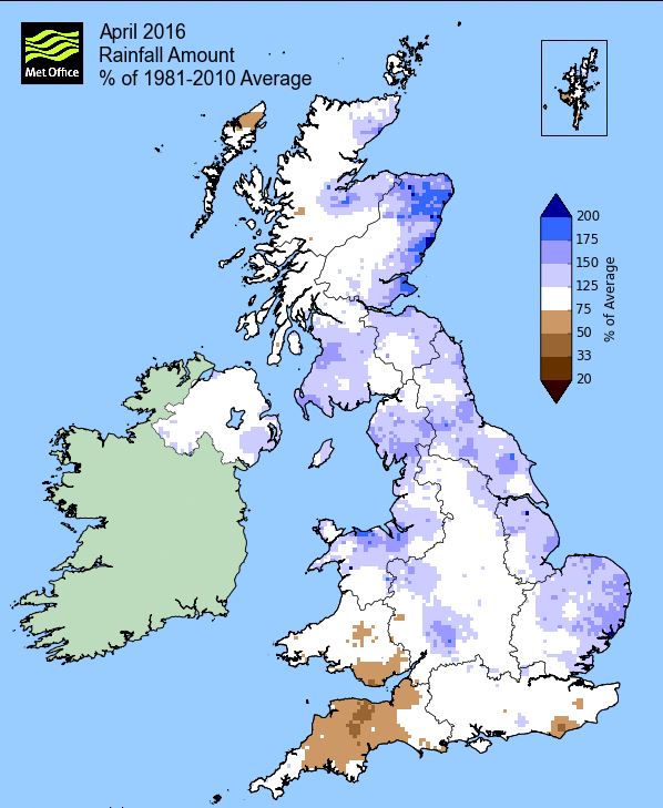
Rainfall of 95.1 mm (Crosby Ravensworth School 102.3 mm - CastleHowe Scar 82.2 mm and at Reagill, 92.5 mm) made it the wettest April of the nine so far recorded here and was 168.3% of average for 2008-15. Locally, rainfall percentages were more typically in the range of 130-140% of normal.
At the Met' Office site at Newton Rigg, 66.0 mm (126.4%) made it the wettest April since 2005 and in a series back to 1900 85 have been drier with 30 wetter and one having the same amount. In a complete series back to 1952 (missing 1955), a mean temperature of 6.1°c is the coldest since 2013 (before that 1989) with 52 having been warmer and 11 colder in that time.
Figures from the Environment Agency’s rainfall sites were, (figure in brackets being the monthly average for 1961-90) ‘Data kindly provided by the Hydrometry and Telemetry team of the Environment Agency (Penrith)’:
Kirkby Thore 68.6 mm (55.4 mm)
Brothers Water 185.37 mm (129 mm)
Nunwick Hall 69.2 mm (45.7 mm) and
263.0 mm at Seathwaite Farm (Borrowdale - 180 mm [average for 1981-2010])
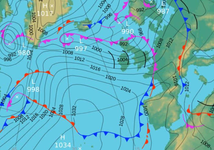
1st - 5th The month started on an unsettled note with low pressure (LP) dominant and rain a regular visitor. LP situated to the south of Greenland during the 1st-2nd pushed a frontal system over the UK bringing that rain which was heaviest during the afternoon and evening of the 1st (16.8 mm), continuing during the morning of the 2nd.
LP then remained over or near to the UK, broadening slightly with the 3rd seeing some hazy sunshine in a SE'ly flow. The period finished with LP systems over Scotland and Cornwall merging and slowly moving away north, giving some rain which tended to fall overnight with the daytime of the 4+5th mainly cloudy. Temperatures whilst not especially high tended to hold up during these few days.
6th - 8th The winds then veered W-WNW'ly over the top of the Azores high that was ridging north and hence it became both cooler and showery. Those winds were quite brisk and the showers both squally and frequent 6-7th, some of those showers on the 7th being of hail.
9th - 16th And still LP was the dominant feature, initially out in the Atlantic pushing fronts and troughs east, later in the period to the south and/or over the UK. Whilst night-time minima tended to hold up under cloudy skies, day-time temperatures were down on average.
The 9th had been a reasonable day until tea-time when a heavy hail shower blew through followed by a wet evening, but overnight the area of LP broadened out and skies cleared to give the first air frost of the month, -2.0°c. The 10th was then a lovely sunny day as the LP and its fronts stayed to our south.
But that LP to our south became responsible for drawing in a cool easterly airflow, albeit with some sunshine on the 10-11th the temperatures were reasonable, 14.5°c on the 11th.
The 12th would become the month's wettest day with 17.7 mm as an occluded front associated to the LP in Biscay moved into northern England. It then joined a new area of LP that was building over the Midlands and which would slowly trundle north, with the occlusion becoming stuck in position as it pivoted away from that new area of LP.
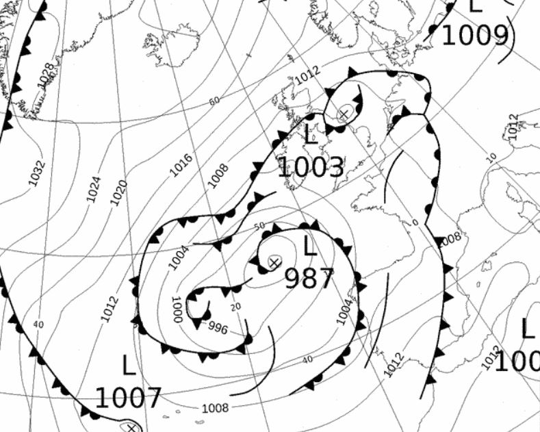 Mid-day 12th - the occlusion that became stuck over northern England
LP still remained near or over the UK for the rest of the period, mainly resulting in cloudy skies and little rain, but on the 14th the winds turned northerly with an incursion of Arctic air and the days became decidedly chilly. The 15th struggled to 7.0°c (44.6°f), only slightly higher on the 16th.
17th - 21st
Spring then felt as it had arrived as high pressure (HP) then became established from the south. After a frontal system cleared away on the 19th, the HP took control giving dry, sunny days and rising temperatures, albeit the nights were rather cool.
Ahead of that weather front, the 17th started in a slack pressure gradient and under clear skies gave the month's coldest temperature of -3.3° (26.1°f) followed by a day of sunny spells. The 18th saw the cold front move south, but which only gave a a few brief spots of rain either side of lunch - and then it was 3˝ days of lovely sunny weather.
The 19th was probably the first day of spring, attaining 14.9°c, followed by 17.1°c (20th) and then a month's high of 18.4°c (65.1°f) on the 21st and we enjoyed wall to wall sun.
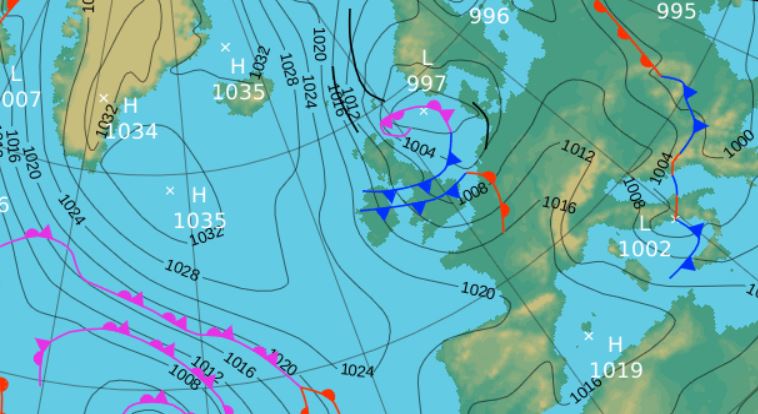
22nd - 24th And of course after spring comes winter! The month which had been running colder than average anyway, now went truly backwards.
The HP of the 17th-21st had elongated east-west from the 20th and now would become dominant in the Atlantic, leaving us on its eastern fringe and in a northerly airflow and susceptible to areas of LP. Ground frost became a common feature and indeed from the 16th every day apart from the 18th recorded one through to the end of the month. Air frosts were less common, but night-time temperatures still came close to freezing on most nights. However, the plunge in day-time temperatures was quite dramatic, after the 18.4°c of the 21st, the 22nd fell away to just 10.5°c and then kept on falling.
However, it was still dry, with cloud tending to build after sunny mornings, but a weak front on the 24th brought a spell of snow in the morning and heralded a change to something even colder!
25th - 30th Hard to believe, but the month finished in the grip of winter and snow became a frequent visitor. The HP in the Atlantic now migrated further west allowing for the full uncontrolled incursion of Arctic air and the day-time temperatures plummeted to even lower than the average for January. With LP near Norway, later Denmark, there was always a frontal system to bring that snow, falling every day during the 26-29th.
It really was quite raw in brisk NW'ly winds and in the frequent spells of snow the temperature plummeted even further, best illustrated on the 28th when the lowest April maximum temperature at this site of just 5.0°c was recorded, but which during some heavy spells of snow in the afternoon fell to just over 1.0°c. The irony of the 28th being the coldest April maximum yet recorded here was that this was the day that I saw the first swallow in the village, the latest date yet.
The snow was at its heaviest during the afternoon of the 28th and for a hour at tea-time on the 27th, the other occasions being mainly in the form of showers, but that which fell in the early hours of the 29th gave a covering on Crosby Ravensworth Fell. That snow on the 28-29th came as a small but vigorous LP system built just west of Eire and moved East over the northern half of the UK. As the centre of the low moved out into the north sea on the 29th it pivoted allowing the associated occlusion to bring more rain and sleet on the 29th.
The 29th saw temperatures lower than the 28th for the majority of the day under leaden skies with frequent light rain and/or sleet, but at tea-time it cleared and a little weak sunshine 'shot' the temperature up above 5.0°. After a hail shower in the morning, the 30th improved to a day of sunny spells.

Rainfall totalled 95.1 mm for the month, with rain recorded on 21 days of which 17 were 'Wet days' (1.0mm +).
The Mean Temperature for the month was 6.06°c -- The Mean Max' was 10.19°c -- The Mean Min' 1.92°c.
We had 7 Air Frosts in the month (year 38) -- Grass frosts totalled 17 (year 76).
The 1 foot soil temp ranged from a low of 6.4°c on the 1st to a high of 9.5°c on the 22nd -- with a monthly mean of 8.0°c
The 1 meter soil temp ranged from a low of 6.8°c on the 1st - 2nd to a high of 8.3°c on the 24-26th -- with a monthly mean of 7.7°c
COMPARISONS:-
* April 2016 rainfall was 168.3% of the April average for 2008 - 2015
* April 2016 was 1.96°c colder than the April average for 2009 - 2015 and 1.3°c colder than the local long term average 1981-2010
* 2015 Jan - April TEMP 4.69°c -- RAIN 432.0 mm
* 2014 Jan - April TEMP 6.26°c -- RAIN 609.2 mm
* 2013 Jan - April TEMP' 3.37°c -- RAIN 262.7 mm
* 2012 Jan - April TEMP' 5.32°c -- RAIN 251.6 mm
* 2011 Jan - April TEMP' 5.80°c -- RAIN 420.9 mm
* 2010 Jan - April TEMP' 3.60°c -- RAIN 158.6 mm
* 2009 Jan - April TEMP' 5.38°c -- RAIN 339.5 mm
* 2008 Jan - April TEMP' -- RAIN 511.3 mm
This makes the Jan' to April period of 2016 0.2°c colder than the average for 2009-15 and with 127.1% of average rainfall for 2008-15
JANUARY 2010
FEBRUARY 2010
MARCH 2010
APRIL 2010
MAY 2010
JUNE 2010
JULY 2010
AUGUST 2010
SEPTEMBER 2010
OCTOBER 2010
NOVEMBER 2010
DECEMBER 2010
JANUARY 2011
FEBRUARY 2011
MARCH 2011
APRIL 2011
MAY 2011
JUNE 2011
JULY 2011
AUGUST 2011
SEPTEMBER 2011
OCTOBER 2011
NOVEMBER 2011
DECEMBER 2011
JANUARY 2012
FEBRUARY 2012
MARCH 2012
APRIL 2012
MAY 2012
JUNE 2012
JULY 2012
AUGUST 2012
SEPTEMBER 2012
OCTOBER 2012
NOVEMBER 2012
DECEMBER 2012
SUMMER 2012
REVIEW OF 2012
JANUARY 2013
FEBRUARY 2013
MARCH 2013
APRIL 2013
MAY 2013
JUNE 2013
JULY 2013
AUGUST 2013
SEPTEMBER 2013
OCTOBER 2013
NOVEMBER 2013
DECEMBER 2013
REVIEW OF 2013
JANUARY 2014
FEBRUARY 2014
MARCH 2014
APRIL 2014
MAY 2014
JUNE 2014
JULY 2014
AUGUST 2014
SEPTEMBER 2014
OCTOBER 2014
NOVEMBER 2014
DECEMBER 2014
WINTER 2014
REVIEW OF 2014
JANUARY 2015
FEBRUARY 2015
MARCH 2015
APRIL 2015
MAY 2015
JUNE 2015
JULY 2015
AUGUST 2015
SEPTEMBER 2015
OCTOBER 2015
NOVEMBER 2015
DECEMBER 2015
REVIEW OF 2015
JANUARY 2016
FEBRUARY 2016
MARCH 2016
© Darren Rogers 2016
Want to comment on this site? email